Showcase Gallery
Highlight

-
Developed by the Transport Department, “HKeMobility” is an all-in-one mobile application that allows users to carry out trip planning through conducting point-to-point route search for public transport, driving, and walking. “HKeMobility” also disseminates real-time traffic updates, parking availability, and estimated arrival times of public transport, so users may obtain personalized, accessible, and multi-modal travel information.
-
The All-in-One Disaster Preparedness Map was developed by the Hong Kong Red Cross, with technical support from the Institute for the Environment at The Hong Kong University of Science and Technology.
-
The Statutory Planning Portal is a digital platform developed by the Town Planning Board to enhance public access to the latest statutory plans and planning information.
-
Centamap developed by Centamap Company Limited is one of the pioneering internet map guides in Hong Kong, utilizing official digital maps from the Lands Department.
-
To safeguard the valuable and unique city skyline of Hong Kong, particularly views to the ridgelines and Victoria Harbour, eight strategic viewing points (SVPs) have been identified for visual impact assessments (VIA) in planning studies and applications.
-
Embee Limited has developed a free real-time air quality monitoring service designed to safeguard student health by providing parents and educators with location-specific air quality information and advice.
-
The Hydrographic Office under the Marine Department developed a tidal data website that visualizes real-time and predicted tide levels via interactive maps and charts.
-
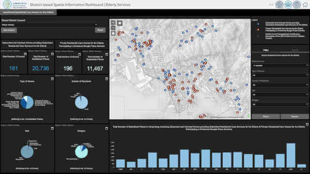
The Census and Statistics Department’s Interactive Data Dissemination Services (IDDSs) and the interactive dashboards showcase regional statistics on establishments and persons engaged in Hong Kong interactively.